Þingvellir (Thingvellir) is Iceland’s national shrine and a place of outstanding scenic beauty
Many of the most momentous events in Icelandic history took place at Thingvellir, where the Alþingi (Althingi), Icelandic parliament, was founded in 930 and continued to assemble every summer until 1798. It was at Thingvellir that the Icelandic nation agreed to adopt Christianity in the year 1000, and the modern republic was founded in 1944. According to legislation from 1928, Thingvellir National Park was established in 1930, the first national park in Iceland. In 2004 Þingvellir National Park was inscribed on the UNESCO World Heritage List.
History of Þingvellir and Alþingi
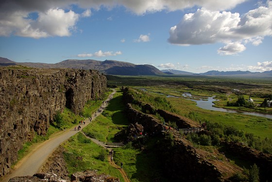
Þingvellir (“assembly plains”) is the site in southwestern Iceland where the ancient general assembly of the Icelanders, Alþingi, met to carry out its duties. The site includes the Lögberg (Law Rock) and the Lögrétta (Law Council). The boundaries were at Kastalar, two lava hills on the northernmost part of Neðri-Vellir (Nedri-Vellir), Lake Þingvallavatn (Thingvallavatn) in the south, the higher wall of the Almannagjá (Almannagja) fault in the west, and Flosagjá (Flosagja) rift, as well as the faults leading from it, in the east.
Alþingi (“general assembly”) was a sovereign legislature, an institution established in order to regulate the common affairs of the country, frame and pass common laws, and arbitrate disputes. Prior to the formation of the Althing, each area of the country had its own local Þing (Thing), assembly headed by the local goði, chieftain-priest. (Thing or ting, þing in Icelandic, is a legislative assembly in Scandinavian countries.)
At Lögrétta (Law Council) the ‘goðar’ (pl. of ‘goði’) – powerful local chieftains, the bishops and their followers gathered to attend to legislative and judicial matters. The Lögsögumaður (Lawspeaker), the president of Lögrétta, would stand on a nearby tall cliff, Lögberg (Law Rock), in Almannagjá and recite the laws from memory. The high lava flank of the fissure behind him gave good acoustics adding resonance to his voice. His words were then recited by other speakers standing on farther cliffs to reach the entire audience. Anyone attending the assembly was entitled to present a case from the Law Rock.
For 868 years every summer, chieftains, bishops, landed farmers and ordinary men and women from all parts of Iceland left their homes and villages and headed towards Thingvellir for the annual fortnight long meeting which would start on the first Thursday in the eleventh week of each summer. The trip on horseback could take up to 17 days from the eastern part of the country. Upon arrival, people set up camp and temporary booths to hold meetings, exchange news, trade and hold games and feasts. The assembly set laws, seen as a covenant between free men, and settled disputes. Religious appointments were made, outlaws banished; marriages were arranged, contracts negotiated, matters of honour decided, sometimes by duels. The plains of Thingvellir turned into a bustling open-air meeting place with huge crowds milling about among tents, booths, rocks, sheep and horses.
Due to its enormous historical and cultural importance, during the period of Iceland’s struggle for independence in the 19th and the 20th centuries, Thingvellir became a sacred place, a powerful symbol of national identity and unity. On the occasion of the establishment of the Republic of Iceland on 17 June 1944, the Althing convened at Lögberg and the constitution of the sovereign Republic was declared to be in force.
Þingvallakirkja (Thingvellir Church) was built soon after the adoption of Christianity. According to Ólafs saga helga (Heimskringla) by Snorri Sturluson, King Olaf Haraldsson (St Olaf) of Norway, who assumed the crown in 1015, sent timber to Iceland, and a church was then built at Thingvellir. The king also sent a big bell with the timber. This church was repaired in the mid-11th century using the timber sent by King Harald Sigurdsson (d. 1066), who also sent a second bell. However, the church was destroyed in a storm in 1118. The present church was built in 1859, and the spire was rebuilt in 1907. The three bells in the belfry include an ancient bell, a bell from 1698, and the bell installed for the independence celebrations in 1944 – “Iceland’s Bell”, the biggest. The first bell given by King Olaf and the second bell given by King Harald, were melted down to make a new bell in 1593. The restored old pulpits are from 1683. The pastor of the church is also the warden at Thingvellir National Park.
Skáldareitur (“poets’ cemetery”), national cemetery, lies to the east of the church. Two prominent poets of the national revival leading to Iceland’s independence, Jónas Hallgrímsson (1807-1845) and Einar Benediktsson (1864-1940), are buried there.
Geology
The Thingvellir National Park covers an area of 237 km2 (heritage sites cover 92.7 km2 – 9,270 ha), located in the Bláskógabyggð (Blaskogabyggd) municipality, about 50 km SW of Reykjavik. The area is part of a fissure zone traversing Iceland, positioned on the Mid-Atlantic ridge. Tectonic plate boundaries separating the North American and the Eurasian plates can clearly be seen on the surface of the Thingvellir rift valley. The site’s geological uniqueness lies chiefly in the fact that it is one of the very few (if any) sites on Earth where the effects of diverging tectonic plates are clearly visible on dry land. Almannagjá at Thingvellir is considered to be one of the best examples of plate tectonics.
Almannagjá (“Everyman’s gorge”) formed about 9000 years ago from extensive layers of basalt lava from the Skjaldbreiður (Skjaldbreidur) shield volcano which flowed down the plateau sitting atop the Mid-Atlantic Ridge where Thingvellir stands today. Later powerful crustal shifts caused the plateau to tend downward rifting the lava in the middle in a SW to NE direction forming a great depression about 40 km long and 10 km wide. The subsidence resulted in the formation of two great chasms at the side of the depression, the 9 km long rift Almannagjá at the west side, with lava walls of 30 m high leading to Thingvallavatn Lake in the south, and Ármannsfell in the north. The lesser Hrafnagjá (Ravens’ chasm) is at the east side. The area between the two rifts subsided as a result of further earthquakes, the last in 1789 when the floor of Thingvellir sank further down about one metre.
Landmarks
Öxará (Oxara), “Axe River”, creates a deep pool Drekkingarhylur. It is likely that already in 999 AD there was a bridge over the river at Thingvellir for the passage of horses and people – as chronicled in the 13th century Kristni saga. The name Axe River was given when the Viking Ketilbjörn the Old lost his axe in the river trying to break the ice to get water.
Öxaráfoss – a small but very beautiful waterfall, especially in winter.
Drekkingarhylur (Drowning pool) – after 1590, women found guilty of adultery, perjury and other offences were drowned in Drekkingarhylur; men were beheaded or hanged. This brutal practice remained in effect until c. 1749.
Lögberg (Law Rock) is no longer visible as it has sunk into the earth due to earthquakes.
Öxarárhólmi – the largest islet in the Öxará. Used as a duelling place in the past.
Valhöll – The booth owned by Snorri Sturluson at Thingvellir.
Thingvallabær – residence of the pastor-warden of Thingvellir and the summer residence the Prime minister.
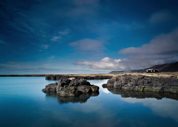
Lake Þingvallavatn (Thingvallavatn) is the largest natural freshwater lake in Iceland, at 84 sq km, about 114 m deep. It has a unique ecosystem, and it’s the only habitat in which four separate morphs of Arctic char have evolved in less than 10,000 years. Additionally, the lake has distinctive stocks of brown trout, as well as interesting birdlife. The lake was formed when the land level sank below the water table level. Its waters are fed from the springs beneath the lava floor. Öxará river also empties into it. Two outlets from the south join Hvítá and Ölfusá rivers in the southern marshlands. The water in the lake is very clear. The lake bottom is visible down to 15 m. It is therefore a very popular diving site and is considered one of the best diving sites in northern Europe.
The nearby Silfra and Davíðsgjá (Davidsgja) submerged fissures have also become extremely popular snorkellingand diving spots due to the exceptional clarity of the water – and the unique experience of diving between two continents. The Davíðsgjá fissure is in the lake itself. Sandey and Nesjaey are volcanic islands in the lake. The largest spring-fed clearwater river in Iceland, Sog, flows out of the lake, 19 km long. It has been harnessed for electricity.
The Act of 1928 establishing the Thingvellir National Park says: “From the beginning of 1930 Þingvellir by the Öxará river and its vicinity shall be a protected national shrine for all Icelanders.”
Of all the phenomena in Icelandic nature and history, Thingvellir is the greatest. The imposing solemn beauty of the surroundings and the entwining of landscape, history and heritage at Thingvellir have been the inspiration for great scholarly, artistic and literary works. For most Icelanders today, Thingvellir remains a sacred place.
Þingvellir National Park Visitor Centre
The Visitor Center is in a building close to the viewspot at Hakið (Hakid), where a footpath leads down into the Almannagjá (Almannagja) rift. The Centre houses the exhibition is based on interactive multimedia, showing the history and nature of Thingvellir.
The Visitor Centre is open daily, 9 am – 5 pm, all year round. A park ranger is always available to assist.


