Iceland’s popular Fimmvorduhals Pass hiking route lies between Myrdalsjokull and Eyjafjallajokull glaciers.
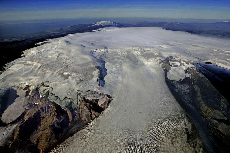
Mýrdalsjökull is the southernmost glacier in Iceland, the fourth largest glacier, with an area of about 596 sq. km. It is located to the north of Vík í Mýrdal (Vik i Myrdal) and to the east of Eyjafjallajökull (Eyjafjallajokull). The popular walking route, Fimmvörðuháls (Fimmvorduhals) Pass, lies between these two glaciers.
The Myrdalsjokull ice cap conceals the upper part of a large volcano, the Katla caldera. Katla is estimated to be around 30 km in diameter, and the caldera itself is estimated to have a diameter of about 10 km. Katla is oval in shape with the longest axis NW-SE and covers an area of 110 sq. km. The highest points of the ice cap lie on the caldera rim and include Goðabunga, Háabunga, Austmannsbunga, Enta and Entukollar. Within the caldera, the ice is hundreds of meters thick. Eruptions can start in many places outside or within the caldera and cause great glacial outburst floods. Quite a few glacier snouts flow down onto the lower lying areas and discharge a great volume of water.
Subglacial eruptions and jökulhlaup
On the morning of 9th July 2011 a short-lived jökulhlaup (glacial outburst flood) occurred. It came from four ice cauldrons in the Katla caldera, possibly caused by a subglacial eruption of the Katla volcano. The Icelandic Met Office gauging station at Selfjall registered that the water level had risen by more than 5 metres within minutes. The bridge over Múlakvísl glacier river, on the main highway Route 1, was swept away and damage caused to the road.
During the summer of 1999 some activity was noted within the Myrdalsjokull caldera. On the night of the 18th of July came a sudden flood in the glacier river Jökulsá á Sólheimasandi, preceded by a burst of seismic tremor. The source of the flood was meltwater from a depression formed on the glacier surface, within the ice drainage basin of Sólheimajökull (Solheimajokull). After the flood, existing depressions enlarged and crevasses were formed. The depressions became deeper during the summer and increased in number. The reason was increased geothermal activity. It’s possible that there was a small subglacial eruption at the head of Sólheimajökull that formed a depression, causing the flood.
Katla erupted very powerfully in 1918 but there is evidence of smaller eruptions after that. Icelandic volcanologists are expecting another eruption in the next few years, so the Myrdalsjokull glacier and the Katla caldera are monitored quite closely.
Volcano-glacial ice interactions
The eruptions of Iceland’s volcanoes which are covered by glacier ice caps have created abundant material for studies in volcanology and glaciovolcanology. As well as providing insights into the Earth’s geological past, studies of Icelandic glaciovolcanoes’ deposits are helping scientists get a better understanding of the Earth’s long term climate cycles, since the volcanic shards also provide clues about the climates of the past. Iceland’s nature continues to offer opportunities for research about the effects that the volcano-ice interactions have on the environment. The impact that these types of volcanic eruptions can have on the Earth´s atmosphere, climate and aviation, for example, is now much better understood.

