The hidden power of Iceland’s Eyjafjallajökull
Eyjafjallajökull (Eyjafjallajokull), “Islands Mountains’ Glacier”, gets its name from the Vestmannaeyjar, Westman Islands, archipelago in its vicinity. Located to the north of Skógar (Skogar) and to the west of the bigger glacier Mýrdalsjökull (Myrdalsjokull), it is a mountain range formed by many eruptions over the course of thousands of years since the Ice Age. Eyjafjallajokull is cone shaped, the 6th biggest glacier in Iceland, covering an area of 78 sq. km.
Several steep glacier tongues protrude from the mountain. Two of them, Gígjökull (Gigjokull) and Steinholtsjökull (Steinholtsjokull), drop into two small proglacial lakes filled with floating calved icebergs. The lake in front of Gigjokull is called Jökullón (Jokullon). There is another, smaller, lake in front of Steinholtsjokull. River Steinholtsá (Steinholtsa) flows out of it into Krossá (Krossa). These lakes are formed by encircling walls built up by tons of terminal moraine.
The ice cap of the glacier conceals the active Eyjafjallajökull stratovolcano (1, 666m in height) which has erupted relatively frequently since the last glacial period. Volcanoes of this kind are also called glaciovolcanoes and, in Iceland, several subglacial volcanoes belong to this category, including the volcanoes Katla, Hekla and Askja.
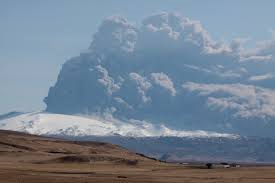
2010 Eyjafjallajokull volcano eruption
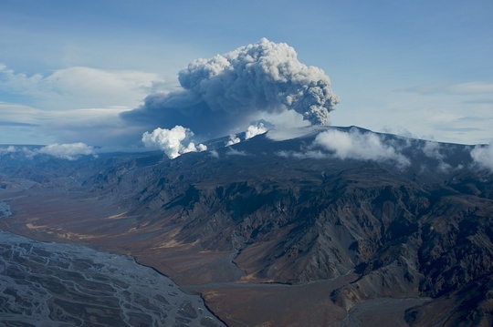
Eyjafjallajokull volcano erupted on 14 April 2010 for the first time after two centuries, bringing Europe’s air travel to a halt, grounding an estimated 10 million travellers worldwide, and focussing a lot of attention on Iceland. The volcano’s 10 week long series of eruptions has been well documented: topics covered ranged from the descriptions of “the power and wrath” of Eyjafjallajokull and the turmoil it brought to stranded passengers, to the predictions on whether or not Iceland´s far more powerful neighbouring volcano Katla might erupt in the aftermath – as it had done it the past.
Earlier eruptions and jökulhlaup
In 1967 there was an enormous landslide onto Steinholtsjokull. On January 15th 1967, at 13:47:55, there was an explosion in the cliff Innstihaus. It can be timed so precisely because the earthquake meters in Kirkjubæjarklaustur (Kirkjubaejarklaustur) picked up the turbulence. When the landslide of about 15 million cubic metres hit the glacier, a huge wave of air, ice, water and huge cliffs started to run from under the glacier and into the lagoon at the foot of the glacier. The wave got as high as 75 metres from the floor of the valley. The cliffs stopped soon afterwards but water and ice touched the floor of the old bridge over Markarfljót (Markarfljot) River one and a half hours later.
The major eruption of 1821-23 caused a disastrous glacier run, jökulhlaup (catastrophic release of water from a glacier, often caused by a subglacial volcanic eruption). The crater of the volcano had a diameter of 3-4 km, the glacier covering an extension of about 100 km².
Under the hills of Eyjafjallajokull now stands the mountain ridge Eyjafjöll (Eyjafjoll), but once it was part of the Atlantic coastline. The sea now being at a distance of about 5 km from there, the former coastline left behind sheer cliffs with a multitude of beautiful waterfalls. The best known waterfall is Skógafoss (Skogafoss). When there are sharp winds, the water from the minor falls is sometimes even blown up the mountain.
The area under Eyjafjoll where now numerous farms stand along the black sand coastal strip was in the past under water, but glacial deposits gradually pushed the coastline into the sea.
Fascinating tours are available, exploring the effects of the Eyjafjallajokull volcano’s 2010 eruption on the landscapes of this part of Iceland, visiting the beautiful waterfalls, and much more.
Eyjafjallajökull subglacial volcano
Eyjafjallajökull volcano is an ice-cap covered stratovolcano located to the north of Skógar (Skogar) and to the west of Mýrdalsjökull (Myrdalsjokull) glacier in southern Iceland.
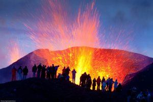
Fimmvorduhals eruption
Preceding the eruption of the Eyjafjallajokull volcano, there was seismic and volcanic activity at Fimmvörðuháls (Fimmvorduhals). The area is located on about a 2 km wide pass of ice-free land between Eyjafjallajokull and the nearby Katla volcano with its overlying cap of the Myrdalsjokull glacier. The initial visual report of the eruption happened around midnight on 20 March 2010 when a red cloud was noticed lighting up the sky above the site. The eruption broke out with fire fountains when about a 500 m long fissure vent opened. Lava flows occurred and a minor plume of less than 1 km. Two new craters erupted about a week later, with spectacular fireworks of magma and lava flows.
2010 Eyjafjallajokull eruption
Located south of the intersection between the South Iceland Seismic Zone and the Eastern Volcanic Zone, Eyjafjallajokull is close to a propagating rift zone – and, close to an inhabited region. On the 14th of April 2010, a phone-call in the dead of night was the first hint that the people living at the foot of Eyjafjallajokull heard that the volcano was about to erupt. The call had come from an Icelandic Civil Protection official. Shortly after, the volcano started erupting from the top crater in the centre of the glacier, where the melt had made its way into the central crater. The eruption unleashed a jökulhlaup (glacial outburst flood), necessitating some 800 people to be evacuated, ejecting an estimated 250 million cubic metres of tephra, and sending a 9 km (30, 000 ft.) high ash plume into the air. After 24 hours, with the volcanic activity still intensifying, the plume had risen to some 11 km, increasing in size several times, as it stretched to eventually cover an area nearly the size of Western Europe. Electrical storms were also observed.
Experts have since suggested that the Eyjafjallajokull eruptions were precipitated by several “microearthquakes”, which, in turn, triggered a chain reaction of expanding magma chambers descending into the Earth at various depths below the surface. At the time, Icelandic scientists had been quick to add more seismometers to the network close to the volcano, enabling collection of excellent satellite imaging data for analysis. The data, and samples of matter spewed from the volcano in the course of the eruptions, have revealed that each separate chamber had contained magma of distinct age and specific geological composition.

