Hengill volcano, geothermal heat & Iceland’s renewable energy
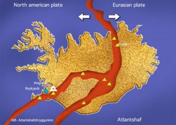
The Hengill volcano mountain range and geothermal field are located in south-western Iceland. The volcano system consists of a series of basaltic fissure vents, crater rows and small shield volcanoes. It lies at the triple junction of the Reykjanes Peninsula volcanic zone, the western volcanic zone and the south Iceland seismic zone. Hengill’s highest peak is 806 m, formed of volcanic ash.
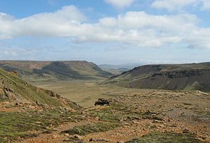
The plateau to the south of the range, Hellisheiði (Hellisheidi), is covered with layers of old and new lava from Hengill’s postglacial lava flows. The latest eruption happened in 1000 AD when Iceland was in the process of Christianization. Kristni Saga, in the Book of Icelanders, makes specific mention of the eruption taking place, just as the issue of acceptance of Christianity is being fiercely debated at the Alþingi (Althing), Icelandic open-air Parliament at Þingvellir (Thingvellir), Parliament Plains. Consequently, the lava field was named Kristnitökuhraun, “Christianity-taking-lava”. Radiocarbon dating has since established that the eruption actually took place at a 5 km distance from Thingvellir at a vent in the Brennisteinsfjöll (Brennisteinsfjoll) volcanic area, on Reykjanes Peninsula.
Other sagas and some folk tales are connected to the region: for example, the tale about the troll woman Jóra who is said to have ensnared innocent wanderers or horsemen on the trail over the Dyrafjöll (Dyrafjoll) mountains, until a young farmer was able to kill her while she slept.
Geothermal energy
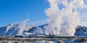
At the foot of the Hengill volcano, there used be the farm Nesjavellir from 1820, but now it´s the home of Iceland’s largest geothermal power plant which produces electricity and provides Reykjavik with most of its hot water. Nesjavellir is an extensive geothermal steam field, one of the largest high-temperature areas in Iceland, whose energy potential is estimated at 180 x 1018 Joule. It is the second largest after Torfajökull (Torfajokull) field. Part of this energy resource is being tapped by the Nesjavellir plant.
Because of the special geological features of Iceland, which include a high degree of volcanism and geothermal phenomena, geothermal energy is being harnessed and very often used for heating and production of electricity. The energy comes rather cheap, so, in the wintertime, some pavements in Reykjavík (Reykjavik) and Akureyri are heated and on the road between Reykjavik and the International Airport at Keflavík (Keflavik) which is 40 km long, the lights on the lamp posts are on the whole night.
The Nesjavellir Power Plant, located at 177 m (581ft.) above sea level on the northeast side of Hengill, supplies 1,100 l/sec of 82-85°C hot water (181.4ºF). The water travels through a 27 km long pipeline (16.78 miles) to the city with a heat loss of only 2°C on the way. The Plant is a combined heat and power plant and provides space heating and hot water for most of the Greater Reykjavik Area. It is the most powerful geothermal well in the world.