The Iceland hotspot and mighty geological phenomena
NEWS ALERT
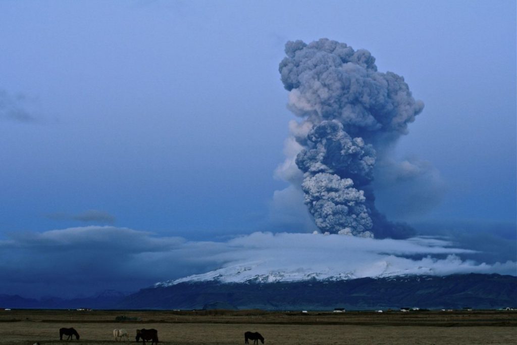
POSSIBLE ERUPTION IN ICELAND
Click the picture above to go to the Icelandic Meteorological Office.
Possible magma accumulation beneath Mt. Thorbjorn on Reykjanes peninsula
Inflation has been detected in the last few days. An earthquake swarm has been ongoing during the same period. A state of uncertainty has been declared. The aviation color code has been raised to yellow for Reykjanes.
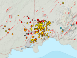
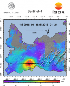
An inflation has been detected since January 21st and is centred just west of Mt. Thorbjorn on Reykjanes peninsula. The inflation is unusually rapid, around 3-4 mm per day and has accumulated to 2 cm to date. It has been detected both on continuous GPS stations and in InSAR images. The inflation is most likely a sign of magma accumulation at a depth of just a few km. If magma accumulation is causing the inflation, the accumulation is very small, with the first volume estimate is around 1 million cubic meters (0,001 km3). This is the conclusion of a meeting held with the Scientific council of the Civil Protection at the IMO this morning.
Accurate measurements of crustal deformation on Reykjanes peninsula span approx. three decades. During this period no comparable signal has been measured. This is unusual for this period. An earthquake swarm has been ongoing, since January 21st, alongside the deformation signal just east of the inflation centre (northeast of Grindavík). The largest earthquakes occurred on January 22nd and were of M3,7 and 3,6. They were felt widely on the Reykjanes peninsula and all the way to Borgarnes region. The earthquake swarm is currently in decline. Swarms like this are common and not unusual by itself in the area. The fact that an inflation is occurring alongside the earthquake swarm is a cause for concern and closer monitoring.
The inflation is centred within an active volcanic zone
The inflation is occurring on plate boundaries and within the volcanic system of Svartsengi which is either considered a separate system or part of the Reykjanes volcanic system. The last known eruption was during Reykjanes fires, which occurred between 1210-1240 AD. Within that period a several eruptions occurred within that system, thereof there were three eruptions in Svartsengi system. The eruptions were effusive (non-explosive) fissure eruptions erupting on 1-10 km long fissures. No explosive eruptions are known from this system. The largest eruption in the swarm, from 13th century, formed Arnarseturshraun lava (estimated 0,3 km3 and 20 km2). Historically, the duration of these eruptions spans from a few days up to several weeks. Seismic activity is very common in this area and is linked to the plate boundaries, geothermal activity and possible magma intrusions. The largest earthquakes measured in this area are about M5.5.
For more information Catalogue of Icelandic volcanoes.
Possible scenarios
The activity has only been ongoing for a few days and it is uncertain if it will escalate to more serious activity. Based on current information, the following scenarios are considered possible, without stating which is most likely or within what timeframe.
1. If the inflation is due to magma accumulation:
• Magma accumulation will cease soon without further activity.
• Magma accumulation continues for some time without further activity.
• Magma accumulation will lead to a magma intrusion.
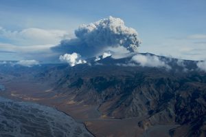
• Magma accumulation will lead to magma intrusion and eruption (effusive fissure eruption).
• Magma accumulation triggers seismic activity with larger earthquakes (up to M6.0).
2. If the inflation is not caused by magma accumulation:
• The inflation might be linked to tectonic activity and lead to larger earthquakes (up to M6.0).
The National Commissioner of the Icelandic Police in cooperation with the Police Commisioner on Reykjanes has declared a state of uncertainty. A public community meeting will be held in Grindavík tomorrow, Monday January 27th at 4pm. There the situation will be discussed with the Department of Civil Protection, scientists and first responders. The 24/7 monitoring of the area has been increased at IMO.
Iceland sits spanning the Mid-Atlantic Ridge tectonic plate boundary which separates the Eurasian and the North American plates. The ridge, an underwater mountain chain, extends about 16,000 km along the north-south axis of the Atlantic Ocean. A rift valley running along its spine is formed by plate tectonics and it’s the locus of new crust formation. Molten lava from beneath the Earth´s crust constantly wells up, cools, and is pushed away from the ridge´s flanks, widening the gap between the continents in the process.
Iceland formed by the coincidence of the spreading boundary of the North American and Eurasian plates and a hotspot or mantle plume – an upsurge of abnormally hot rock in the Earth´s mantle. As the plates moved apart, excessive eruptions of lava constructed volcanoes and filled rift valleys. Subsequent movement rifted these later lava fields, causing long, linear valleys bounded by parallel faults. The divergence of the ridge started in the north about 150 million years ago and 90 million years ago in the south. These movements continue today, accompanied by earthquakes, reactivation of old volcanoes, and creation of new ones. Iceland is the largest island on the ridge because of the additional volcanism caused by the hotspot under the country, the Iceland plume, which is moving slowly across towards the northwest. Other islands of the Atlantic Ocean created by the volcanism of the Mid Atlantic Ridge are The Azores, Bermuda, Madeira, The Canary Islands, Ascension, St Helena and Tristan da Cunha.
———————————————————————————————————————————————————
Volcanism in Iceland
Because Iceland lies on the Mid-Atlantic Ridge, it is being split by the movements of the shifting tectonic plates. The plates are moving apart, one to the east, the other to the west, and both the North American and the Eurasian systems are moving to the northwest across the hotspot. On top of hotspots there is generally a 20-100% molten layer at the depth of 5-20 km, which supplies sufficient material for eruptions. Iceland is home to more than 100 volcanoes, around 35 of which have erupted in recent history. The volcanism on Iceland is attributed to the combination of Mid-Atlantic Ridge activity and hotspot activity. Eruptions occur about every 5-10 years and primarily consist of basaltic lava and tephra. A few long-lived centres, such as the volcano Hekla, erupt more silicic magmas. The hotspot causes eruptions within the southern volcanic zone including volcanic systems such as Mt Hekla, Vestmannaeyjar (the Westman Islands), Katla caldera, Eyjafjallajökull (Eyjafjallajokull), the Laki area and the western subglacial part of the Vatnajökull (Vatnajokull) area where Grímsvötn (Grimsvotn) volcano is the most active.
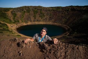
Some of the most active areas of new crust formation are in the south-western parts of Iceland, accessible to tourists. The trip from Keflavík (Keflavik) airport to Reykjavík (Reykjavik) takes you along the edge of the North American plate where it meets the Eurasian plate. A drive to nearby Þingvellir (Thingvellir) valley, the site of the world’s first parliament, reveals an older part of the rift system, where you can see both sides of the plates´ boundary in one sweeping panorama. A flight to the island of Heimaey gives you a glimpse of the new land forming and of the hazards of living in the path of a spreading rift.
Landforms
Iceland can be divided into three zones based on the age of the basaltic rocks. Tertiary flood basalts make up most of the northwest quadrant of the island. This stack of lava flows is at least 3,000 m thick. Quaternary flood basalts and hyaloclastites are exposed in the central, southwest and east parts of the island. The Quaternary rocks are cut by the neovolcanic zone, areas of active rifting that contain most of the active volcanoes. The rifts are topographic depressions bordered by and containing many faults. Fissure swarms make up most of the neovolcanic zone. The swarms are 5-10 km wide and 30-100 km long. The rift zones have opened about 30 m in the last 3,000-5,000 years. The neovolcanic zone is about one-third of the area of Iceland. Almost 60% of the world’s regional fissure eruptions have been in Iceland.
Volcanic eruptions
Iceland is one of the most active volcanic regions on Earth. It is estimated that 1/3 of the lava erupted since 1500 AD was produced in Iceland. Iceland has 35 volcanoes that have erupted in the last 10,000 years. Eleven volcanoes erupted between 1900 and 1998: Krafla, Askja, Grimsvotn, Loki – Fögrufjöll (Fogrufjoll), Bárðarbunga (Bardarbunga), Kverkfjöll (Kverkfjoll), Esjufjöll (Esjufjoll), Hekla, Katla, Surtsey, and Heimaey. Most of the eruptions were from fissures or shield volcanoes and involve the effusion of basaltic lava.
Iceland was buried under ice in the last Ice Age and all eruptions were subglacial. Fragments of the ice caps remain and Iceland continues to have numerous subglacial eruptions. Of the world’s known subglacial eruptions, 83% are in Iceland. The eruption at Grimsvotn is an example. Subglacial eruptions produce a special type of volcano, called a table mountain or a moberg mountain. Great volumes of meltwater, generated by subglacial eruptions, can burst out from beneath glaciers to produce enormous glacial floods called jokulhlaup. The discharge can be as much as 20 times greater than the flow rate of the Amazon River.
The 1783 eruption at Laki was the largest single historic eruption of basaltic lava (14.7 cubic km). Recent eruptions include the 1974-1984 eruption at Krafla, a brief eruption at Hekla in 1991 and again on February 26, 2000, the Eyjafjallajökull eruption in 2010 and four eruptions at Grimsvotn: in 1996, 1998, 2004 and 2011.