Iceland’s Katla is one of the world’s most powerful volcanoes
The home of the Katla volcano is Mýrdalsjökull (Myrdalsjokull) glacier, the southernmost glacier in Iceland, almost 600 km2 large, and the 4th biggest glacier in Iceland. Myrdalsjokull´s ice cap hides the Katla caldera. Katla erupted very powerfully in 1918 but there has been evidence of smaller eruptions since then. Icelandic volcanologists are expecting another eruption in the next few years, so Myrdalsjokull and the Katla caldera are being monitored quite closely.
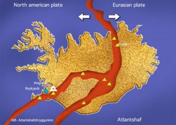
Katla volcano is subglacial, basaltic-to–rhyolitic, and it has the reputation of being one of the most dangerous volcanoes of Iceland. Since the Laki craters and the Eldgjá (Eldgja) fissure system are part of the same volcanic system, Katla can be regarded as one of the most powerful volcanoes in the world.
In 934 AD, the Eldgjá basaltic eruption in Iceland produced nearly 20 cubic km of lava, from a 30-km long fissure. The Eldgjá eruption is the largest flood basalt (basaltic flood eruption) in historic times, covering an area of approximately 800 sq. km. The eruption lasted 3-8 years. Eldgjá means “Fire canyon”, or “Fire fissure”, in Icelandic.
Katla is about 30 km in diameter with a crater of 10 km in diameter. The volcano´s highest part reaches 1512 m above sea level. Within Katla caldera, situated beneath the centre of Myrdalsjokull, the ice is hundreds of metres thick. The caldera is oval in shape with the longest axis NW-SE up to 750 m deep, covering an area of 110 km2. The highest points of the ice cap lie on the caldera rim and include Goðabunga (Godabunga), Hábunga (Habunga), Austmannsbunga, Enta and Entukollar. Eyjafjallajökull (Eyjafjallajokull), a much smaller (50 km²) glacier, is just west of Katla and Myrdalsjokull glaciers.
Katla eruptions
During the summer of 1999 some activity was noted within the Myrdalsjokull caldera. On the night of the 18th of July came a sudden flood in the river Jökulsá (Jokulsa) á Sólheimasandi. The source of the flood was meltwater from a depression formed on the glacier surface, within the ice drainage basin of Sólheimajökull (Solheimajokull). After the flood, existing depressions enlarged and crevasses were formed. The depressions became deeper during the summer and increased in number. The cause was the increased geothermal activity. It is possible that a small eruption at the head of Solheimajokull formed a depression and caused the flood.
Before Hringvegur, Route 1 or the Ring Road, Iceland´s national motorway had been constructed, people feared traversing the plains in front of the volcano because of the often occurring glacier runs, and the deep rivers to cross. Especially fatal was the glacier run after the eruption of 1918. Icebergs the size of houses were seen floating out to sea. More recently, in 1955 and 1979, there have been floods though no eruption that you could see.
From the time when Iceland was settled in the ninth century, Katla has erupted on average every 60 years. Through the ages many farms have been swept away by Katla eruptions, with that of 1311 being recorded as particularly damaging. A farmer named Sturla is said to have survived with his young son by clinging to an iceberg which later drifted back to shore. An eighteenth century eruption killed several people while others were stranded for days on mountains that turned to islands as floods engulfed the plains.
Jökulhlaup
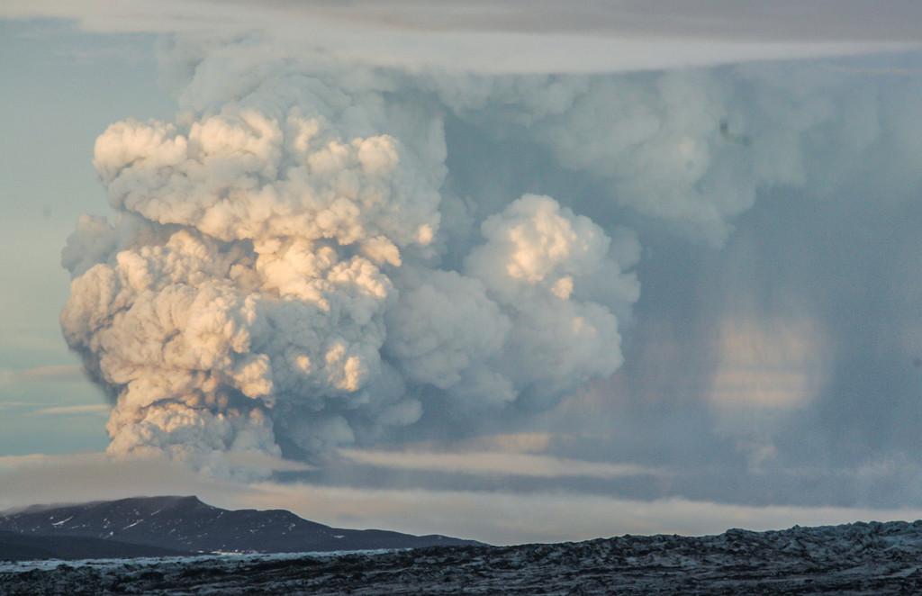
A jokulhlaup – “glacier run” (literal translation of the Icelandic word jökulhlaup), or glacier outburst flood, is usually due to an eruption of a subglacial volcano. The ice over the volcano melts because of the heat, causing the water to form a lake under the remaining ice cap. Then the ice cap collapses, or the water breaks through the barrier in front of it, and there follows a more or less disastrous flooding of the land below the mountain. A glacier run is a type of lahar.
It is not by chance that the term jokulhlaup comes from Icelandic, as the south of Iceland has very often been victim to such catastrophes. When in 1996 the volcano under the Grímsvötn (Grimsvotn) lakes belonging to the Vatnajökull (Vatnajokull) glacier erupted and the river Skeiðará (Skeidara) flooded the land in front of Skaftafell National Park (now integrated with the Vatnajokull National Park), the glacier run reached 50, 000 m3 per second and destroyed parts of the Route 1 national motorway. The damage caused to the roads and bridges was colossal, as everything that stood in the path of the nearly 4 m high and 600 m wide deluge was demolished. After the flooding, icebergs 10 m high could be seen on the banks of the river where the jokulhlaup had left them behind.
Since 1996 the volcano under Grimsvotn has erupted three times: in 1998, 2004 and 2011. The glacier outburst floods that followed were nowhere near the catastrophic one in 1996.
| Eruption site | Year / Century | Date | Duration (days) |
| Katla | 2011 | (small subglacial eruption) | |
| Katla | 1955 | (small subglacial eruption) | |
| Katla | 1918 | 12 October | 24 |
| Katla | 1860 | 08 May | 20 |
| Katla | 1823 | 26 June | 28 |
| Katla | 1755 | 17 October | ~120 |
| Katla | 1721 | 11 May | ~100 |
| Katla | 1660 | 03 November | ~60 |
| Katla | 1625 | 02 September | 13 |
| Katla | 1612 | 12 October | |
| Katla | 1580 | 11 August | |
| Katla | ~1500 | ||
| Katla | 15th century | ||
| Katla | 1416 | ||
| Katla | ~1357 | ||
| Katla | 1311 | 18 January | |
| Katla | 1262 | ||
| Katla | 1245 | ||
| Katla | ~1179 | ||
| Katla | 12th century | ||
| Eldgjá-Katla | ~934 | ||
| Katla | ~920 | ||
| Katla | late 9th or early 10th century | ||
Iceland’s first geopark, Katla Geopark, takes its name from the Katla volcano. Katla Geopark covers an area of 9542 sq. km, (about 9% of Iceland) and encompasses volcanoes, glaciers, black sandy beaches, glacial rivers, lakes, waterfalls and vast lava fields.