Iceland’s Langjökull glacier
Langjökull, “The Long Glacier” (1,360 m, 4,460 ft.) is the second largest in Iceland. It has an area of about 950 km² and most of it rises between 1,200 and 1,300 m above sea level. It rests on a massif of hyaloclastite mountains. They rise highest under Langjokull’s southern and northern parts, but have not yet been researched thoroughly.
Four counties meet in Langjokull area: Árnessýsla (Arnessysla), Borgarfjarðarsýsla (Borgarfjardarsysla), Mýrarsýsla (Myrarsysla) and Húnavatnssýsla (Hunavatnssysla).
The Iceland Glaciological Society owns a hut at the foot of the nunatak Fjallkirkjan (1,228 m). Many glacier snouts crawl down to the lower lying areas and each of them has a name.
There are three smaller glaciers around the big one: to the northwest is Eiríksjökull (Eiriksjokull), to the south is Þórisjökull (Thorisjokull) and to the east is Hrútfell (Hrutfell).

Kaldidalur & Kjölur
Two of the bigger highland tracks lead alongside this glacier: Kaldidalur Highland road and Kjölur (Kjolur) Highland road. Kaldidalur is between Langjokull and the glacier Ok in the west, whereas Kjölur lies between Langjokull and Hofsjokull in the east.
Very little water runs from Langjökull glacier on the surface. However, by sub-surface streams, Langjokull supplies Þingvallavatn (Thingvallavatn) – the largest natural lake of the country, the lakes to the North, the geothermal areas in the West, as well as the Geysir area.
Langjökull volcano
Concealed by the ice cap, the Langjokull central volcano lies at the northern end of an active volcanic zone that extends to the NE from the Reykjanes Peninsula. Langjokull volcano occupies the NE half of the massive Langjokull ice cap, east of the prominent Pleistocene table mountain, Eiriksjokull. A summit caldera lies beneath the ice. Several shield volcanoes have been constructed along flank fissure zones, and postglacial lava flows flank Langjokull on the northern, western, and eastern sides. One of the most prominent of these is a small shield volcano that was formed at the site of the massive Hallmundahraun lava flow, which covers 200 sq. km, which erupted shortly after 900 AD.
The Geysir geothermal area, containing Iceland’s largest geysers, lies in the Haukadalur basin, near the southern end of the lengthy fissure system extending from Langjokull central volcano. Some of the most exceptional natural phenomena of Iceland can be seen there, including the geysers Strokkur and Geysir, hot spring Blesi with its beautiful surreal colours, as well as other geothermal features on the Laugarfjall rhyolitic dome.

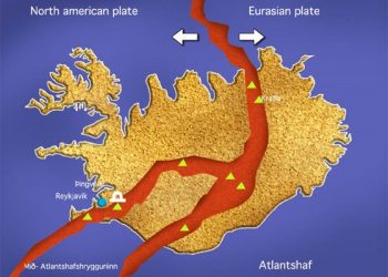
Organized snowmobile and snow scooter tours are available on Langjokull glacier. In addition, the brilliantly planned Golden Circle + Glacier day tour from Reykjavik enables you to visit Langjokull glacier, as well as to see Thingvallavatn, the tectonic plate boundaries and the Viking Parliament Althingi at Thingvellir National Park, the geyser Strokkur, and the beautiful Gullfoss waterfall. This guided super-jeep tour is among the most popular day tours from Reykjavik.


